Botev Point
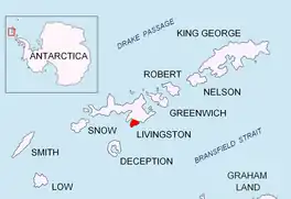
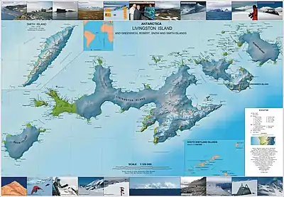
Botev Point (Bulgarian: нос Ботев, romanized: nos Botev, IPA: [ˈnɔz ˈbɔtɛf]) is the south extremity of both Rozhen Peninsula and Livingston Island in the South Shetland Islands, Antarctica formed by an offshoot of Botev Peak in the Veleka Ridge of Tangra Mountains.
The feature is named after Hristo Botev (1848–1876), poet and leader of the Bulgarian liberation movement.
Location
The point is located at 62°45′49.6″S 60°18′46″W which is 1.5 km east-southeast of Barnard Point, 5.1 km west-southwest of Gela Point and 9.29 km west-southwest of Samuel Point. The point was mapped in 1968 by the UK Directorate of Overseas Surveys, and in 2005 and 2009 by Bulgaria.
Maps
- L.L. Ivanov et al. Antarctica: Livingston Island and Greenwich Island, South Shetland Islands. Scale 1:100000 topographic map. Sofia: Antarctic Place-names Commission of Bulgaria, 2005.
- L.L. Ivanov. Antarctica: Livingston Island and Greenwich, Robert, Snow and Smith Islands. Scale 1:120000 topographic map. Troyan: Manfred Wörner Foundation, 2009. ISBN 978-954-92032-6-4
References
- Botev Point. SCAR Composite Gazetteer of Antarctica.
- Bulgarian Antarctic Gazetteer. Antarctic Place-names Commission. (details in Bulgarian, basic data in English)
External links
- Botev Point. Copernix satellite image
This article includes information from the Antarctic Place-names Commission of Bulgaria which is used with permission.