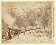
Black Hills and Fort Pierre Railroad
The Black Hills and Fort Pierre Railroad (BH&FP) was a 3 ft (914 mm) narrow gauge[1] railroad in the Black Hills of the U.S. state of South Dakota. It was created by the Homestake Mining Company and initially ran from Lead to Calcite and Piedmont by way of Elk Creek. An alternate route was established to Piedmont and Calcite by way of Nemo and Stagebarn Canyon after numerous washouts made the Elk Creek route unviable. There was also a branch from the Nemo line connecting Este with a logging camp at Merritt. The railroad had 6.180 miles (9.946 km) of dual gauge track (with 4 ft 8+1⁄2 in (1,435 mm) standard gauge trackage) and another 47.618 miles (76.634 km) of 3 ft (914 mm) track; the total amount of track was 53.798 miles (86.579 km).[2][3]
| Overview | |
|---|---|
| Headquarters | Lead, South Dakota |
| Locale | Black Hills, South Dakota |
| Dates of operation | 1882–1932 |
| Technical | |
| Track gauge | 3 ft (914 mm) |
| Length | 53.798 miles (86.579 km) |
History

The line was originally intended to haul timber to the Homestake Mining Company in Lead. On June 15, 1881, the railroad company was incorporated under the name Black Hills Railroad Company. The name was changed to the Black Hills and Fort Pierre Railroad on July 10, 1882.[2] On November 29, 1881, a mule team hauled the first locomotive, a Porter 2-6-0, from Fort Pierre to Lead. The first track was laid from Lead to Woodville in 1881, and in 1886, the track was extended 15 miles (24 km) to Bucks. In 1890, the line was extended 21.5 miles (34.6 km) to Piedmont. A line 14 miles (23 km) long that ran from Bucks to Este was built in 1898.[4]
On July 28, 1901, the Burlington and Missouri River Railroad, which was a subsidiary of the Chicago, Burlington and Quincy Railroad (CB&Q), bought the railroad.[4] The CB&Q handled construction after July 1901.[2] The three-rail line was then built from Lead to the Homestake Mine. In 1906, a small line was created from Este to Merritt, and was about 4 miles (6.4 km) long. A flood wiped out about 15.5 miles (24.9 km) of track from Bucks to Calcite and had to be replaced by a new line from Este to Stage Barn Canyon, where it would connect to a surviving line. In the 1920s, increasing automobile traffic led to the decline of the railroad. The Calcite Mine, the only source of traffic remaining on the railroad at the time, was planned to shut down. On October 25, 1929, plans to shut down the railroad were completed; permission to do so from the state and federal governments was received on December 14. The railroad operated until March 20, 1930, and the track was dismantled that spring. The company was officially disestablished in 1932.[4]
Footnotes
- Railroad Line Forums - Narrow Gauge to the Black Hills Boom Towns Archived March 3, 2016, at the Wayback Machine
- Strouse (1928).
- "South Dakota's Railroads: An Historic Context" (PDF). South Dakota State Historical Society. South Dakota Historic Preservation Office. December 2007 [First published 1998]. Archived from the original (PDF) on 2013-11-11. Retrieved January 20, 2014.
- Hilton (1990).
References
- Hilton, George W. (1990). American Narrow Gauge Railroads. Stanford, California: Stanford University Press. ISBN 0-8047-2369-9.
- Strouse, L.K. (1928). Interstate Commerce Commission Reports: Decisions of the Interstate Commerce Commission of the United States. Interstate Commerce Commission.
External links
- Historic American Engineering Record (HAER) No. SD-52, "Black Hills and Fort Pierre Railroad Roundhouse, Terraville Avenue and Sunnyhill Road, Lead, Lawrence County, SD", 23 photos, 3 measured drawings, 26 data pages, 2 photo caption pages