Berlin Turnpike
The Berlin Turnpike is a 12.17-mile (19.59 km) four- to six-lane expressway carrying U.S. Route 5 (US 5) and Route 15 in New Haven County and Hartford County in the U.S. state of Connecticut. The road begins one mile south of the Meriden-Berlin town line where Route 15 on the Wilbur Cross Parkway merges with US 5 along North Broad Street in Meriden and terminates at the Hartford city line. The local name of the street varies as it passes through multiple towns.
Berlin Turnpike | |
|---|---|
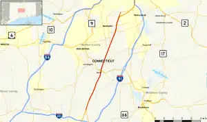 Map of central Connecticut with Berlin Turnpike highlighted in red | |
| Route information | |
| Maintained by ConnDOT | |
| Length | 12.17 mi (19.59 km) |
| Existed | 1909–present |
| Component highways | |
| Major junctions | |
| South end | |
| North end | Maple Avenue in Hartford, Connecticut |
| Location | |
| Country | United States |
| State | Connecticut |
| Counties | New Haven, Hartford |
| Highway system | |
| |


1.07 miles (1.72 km) south of the Hartford city line, US 5 and Route 15 leave the turnpike and follow the Wilbur Cross Highway northeast through Hartford towards the Charter Oak Bridge. The Berlin Turnpike continues north as part of Route 314 for 0.69 miles (1.11 km), and then as the unsigned State Road 543 for 0.38 miles (0.61 km) before entering Hartford as the municipally-maintained Maple Avenue.
Route description

The Berlin Turnpike begins at a fork interchange between Route 15, which continues south as the controlled-access Wilbur Cross Parkway, and US 5, which continues south as a local road named Broad Street. The turnpike is the only segment of Route 15 that is not a freeway, as it has multiple at-grade intersections, some with traffic lights, as well as businesses on both sides of the road. The turnpike has grade-separated interchange with Route 9 and Route 372 in Berlin, as well as Route 175 on the border between Newington and Wethersfield.[1]
In Wethersfield, US 5 and Route 15 leave the turnpike for the controlled-access Wilbur Cross Highway heading towards Hartford. This is the western terminus of Route 314, which takes a right turn onto Jordan Lane soon after to actually proceed in the eastbound direction. From Jordan Lane to the city line, the turnpike is unsigned SR 543. At the city line, the road becomes Maple Avenue and continues north towards Downtown Hartford.[1]
History
The Hartford and New Haven Turnpike was a toll road chartered in 1798 and built in 1798-99 to connect the cities of New Haven and Hartford in the U.S. state of Connecticut.[2] The turnpike was built to connect the courthouses of New Haven and Hartford in as straight of a route as allowed by the terrain. Its southern terminus was at Grove Street,[2] which forms the northern boundary of the original nine squares of New Haven. The road's straight line principle caused several intermediate town centers to be bypassed.
Since the turnpike's original construction, the roadway has been realigned and substantially widened to become the Berlin Turnpike that it is today — a major commercial thoroughfare. Many parts of the original alignment are maintained as local roads or unsigned state roads.
Major intersections
| County | Location | mi | km | Destinations | Notes |
|---|---|---|---|---|---|
| New Haven | Meriden | 0.00 | 0.00 | Route 15 continues south along the Wilbur Cross Parkway | |
| Interchange; southern end of US 5 concurrency; southbound exit and northbound entrance | |||||
| Hartford | Berlin | 4.69– 5.05 | 7.55– 8.13 | Interchange; exits 31-32 on Route 9; southbound access to Route 372 via Worthington Ridge Road (SR 572) | |
| 5.87 | 9.45 | West end of Route 160 | |||
| Newington | 7.37 | 11.86 | South end of Route 173 | ||
| 7.99 | 12.86 | South end of Route 176 | |||
| 9.38 | 15.10 | West end of Route 287 concurrency | |||
| 9.45 | 15.21 | Eastern end of Route 287 concurrency | |||
| Newington–Wethersfield line | 10.08 | 16.22 | Interchange | ||
| Wethersfield | 11.10 | 17.86 | Interchange; northern end of US 5/Route 15 concurrency; western terminus of Route 314; northbound exit and southbound entrance | ||
| 11.79 | 18.97 | Route 314 continues east; western terminus of unsigned SR 543 | |||
| Wethersfield–Hartford line | 12.17 | 19.59 | Maple Avenue north | Continuation into the City of Hartford; eastern terminus of unsigned SR 543 | |
1.000 mi = 1.609 km; 1.000 km = 0.621 mi
| |||||
References
- Google (February 2, 2020). "Berlin Turnpike" (Map). Google Maps. Google. Retrieved February 2, 2020.
- William Phipps Blake (1888). History of the Town of Hamden, Connecticut. Price, Lee & Company. pp. 93–94.
- De La Torre, Vanessa (June 26, 2007). "Police Have Eyes On Road". The Hartford Courant. Retrieved February 2, 2020.