Bennetts Corner, Pennsylvania
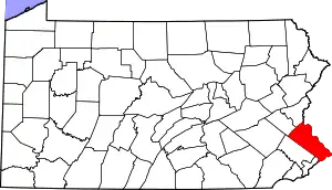
Bennetts Corner is a populated place in Solebury Township, Bucks County, Pennsylvania at the intersection of Edison Furlong Road and Pebble Hill Road about 2 miles (3.2 km) southeast of Doylestown.[1]
Bennetts Corner | |
|---|---|
Populated place | |
 Bennetts Corner Bennetts Corner, Doylestown Township  Bennetts Corner Bennetts Corner (the United States) | |
| Coordinates: 40°17′23″N 75°6′2″W | |
| Country | United States |
| State | Pennsylvania |
| County | Bucks |
| Elevation | 217 ft (66 m) |
| Time zone | UTC-5 (EST) |
| • Summer (DST) | UTC-4 (EDT) |
| ZIP code | 18901 |
| Area codes | 215, 267, 445 |
History
Bennetts Corner was named from the Bennett family who owned land in the area prior to 1870, and has been known by this name since the mid-1800s.[2]
Geography and statistics
Bennetts Corner was entered into the Geographic Names Information System on 2 August 1979 as identification number 1203065, its elevation is listed as 217 feet (66 m). An unnamed tributary of the Neshaminy Creek, part of the Delaware River watershed runs through the village. It is located in the Doylestown (18901) Zip code, and the telephone Area codes 215, 267, and 445.[3][1]
References
- https://viewer.nationalmap.gov/advanced-viewer/ Archived 2012-03-29 at the Wayback Machine The National Map, retrieved 4 December 2018
- MacReynolds, George, Place Names in Bucks County, Pennsylvania, Doylestown, Bucks County Historical Society, Doylestown, PA, 1942, Page 22.
- "Bennetts Corner". Geographic Names Information System. United States Geological Survey, United States Department of the Interior.
This article is issued from Wikipedia. The text is licensed under Creative Commons - Attribution - Sharealike. Additional terms may apply for the media files.
