Baxter Boulevard
Baxter Boulevard is a boulevard and parkway in Portland, Maine. The roadway served as the means to head north from downtown Portland before Tukey's Bridge, now on Interstate 295 (I-295), was built. The road was part of U.S. Route 1 (US 1) until May 2007. The parkway wraps around the west side of Back Cove estuary basin.
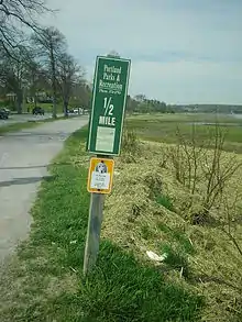
 A distance marker on the western side of Baxter Boulevard. | |
| Maintained by | City of Portland, Maine |
|---|---|
| Location | Portland, Maine |
| Construction | |
| Completion | 1917 |
The parkway and roadway began as an initiative of Mayor James Phinney Baxter, for whom it is named. It was envisioned as one of four parks in the city (along with Deering Oaks, Western Promenade and Eastern Promenade) which would encircle the city. The parkway was designed by the noted landscape design firm Olmsted, Olmsted and Eliot in 1895.[1] Property owners donated the then-useless land next to the cove and the walking and biking path were filled in. Originally called the Back Cove Boulevard, the parkway opened in 1917. It covers 30 acres (12 ha) and the pathway is 2.25 miles (3.62 km) in length.[2]
Tree planting began on the Boulevard in 1921 as a memorial to World War I victims.[3]
Baxter Boulevard was listed on the National Register of Historic Places as a historic landscape district in October 1989.[4]
References
- "NRHP nomination for Back Cove". National Park Service. Retrieved 2015-10-29.
- Portland City Guide Page 291
- Adams, Herb (1999). Holtwijk, Theo H.B.M.; Shettleworth Jr., Earle G. (eds.). Bold vision: the development of the parks of Portland, Maine. Published for Greater Portland Landmarks, Inc. by Phoenix Pub. ISBN 0939761068.
- "National Register Information System". National Register of Historic Places. National Park Service. July 9, 2010.