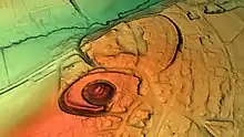
Barwick-in-Elmet Castle
Barwick-in-Elmet Castle was a fortification in the village of Barwick-in-Elmet, West Yorkshire, England to the east of Leeds (grid reference SE398375).

The site of the castle was originally an Iron Age hill fort, the remains of which can be seen even today, and coins dating from the first and second century BC have been discovered in the area.[1] The Romans constructed a bulwark on the northern part of the elevated ground that is nowadays known as Wendel Hill. The village was further developed and fortified during the Dark Ages and became known as the seat of the Kings of Northumberland during the heptarchy, who also housed their granary in the village.[2] According to some sources[3] it was Edwin, King of Northumberland who resided here. After the Norman Conquest the manor house and the lands were awarded to Ilbert de Lacy, the Earl of Lincoln who erected a motte and bailey fortification on a steep elevated hilltop, that came to be known as the Hall Tower Hill.[4][5][6] It seems to have had an outer wall as well, surrounded by two trenches, the inner of which according to sources was about thirty three feet deep.[7] After the Lacy's, it was the Duke of Lancaster who took possession of the manor house and the lands.[3]

Most of the bailey to the east of Hall Tower Hill has now been built on and destroyed.[8] However the remains of the trench that surrounded the castle are visible, but it now measures only around 14 feet deep.[1]
Notes
- Historic England. "Barwick in Elmet large univallate hillfort and motte and bailey castle, Barwick in Elmet and Scholes (1010924)". National Heritage List for England. Retrieved 9 March 2020.
- Bogg, Edmund (1902). The old kingdom of Elmet: York and the Ainsty district: a descriptive sketch of the history, antiquities, legendary lore, picturesque feature, and rare architecture. J. Heywood.
- Moule, Thomas (1837). The English Counties Delineated: Or, A Topographical Description of England. G. Virtue.
- England's Gazetteer; Or, An Accurate Description Of All The Cities, Towns, and Villages of the Kingdom: In Three Volumes. Vol. I. and Vol. II. Contain A Dictionary of the Cities, Corporations, Market-Towns, and the Most Noted Villages; Their Manufactures and Trade; Markets, Fairs, Customs, and Prilileges; Principal Buildings, and Charitable Foundations, &c. With Their Distance from London, in Miles Both Computed, and Measured. Vol. III. A New Index Villaris, Or, Alphabetical Register of the Less Noted Villages; With Their Distance, Or Bearing, from the Next Market-Town, Or Well-known Place. This Work Includes All the Chief Harbours, Bays, Forests, Hills, Mines, Medicinal Springs, Moors, and Other Curiosities Both of Nature and Art; and Not Only Takes Notice of Most of the Manors and Seats in the Kingdom, Both Ancient and Present; But Also Points Out the Old Military Ways, Camps, Castles, and Other Remarkable Ruins of Roman, Danish, and Saxon Antiquity: - And Particularly Shews the Estates Were Formerly Abbey-Lands. Knapton, Brown, Millar, Whiston and White. 1751.
- Aslet, Clive (4 October 2010). Villages of Britain: The Five Hundred Villages that Made the Countryside. A&C Black. ISBN 978-0-7475-8872-6.
- Luckombe, Philipp (1790). England's Gazetteer.
- Cox, Thomas (1738). Westmorland - Yorkshire. sold.
- "Hall Tower Hill and Wendel Hill - Barwick in Elmet". Brigantes Nation. Archived from the original on 12 December 2007. Retrieved 16 December 2007.
Bibliography
- Fry, Plantagenet Somerset (1980). The David & Charles Book of Castles. Newton Abbot: David & Charles. p. 184. ISBN 0-7153-7976-3.