Bakers Creek (Cape Fear River tributary)
Bakers Creek is a 4.81 mi (7.74 km) long 3rd order tributary to the Cape Fear River in Bladen County, North Carolina.
| Bakers Creek Tributary to Cape Fear River | |
|---|---|
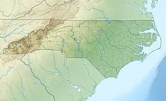 Location of Bakers Creek mouth  Bakers Creek (Cape Fear River tributary) (the United States) | |
| Location | |
| Country | United States |
| State | North Carolina |
| County | Bladen |
| Physical characteristics | |
| Source | Bear Ford Swamp divide |
| • location | Dublin, North Carolina |
| • coordinates | 34°39′52″N 078°42′46″W[1] |
| • elevation | 126 ft (38 m)[2] |
| Mouth | Cape Fear River |
• location | about 1 mile south of Yorick, North Carolina |
• coordinates | 34°39′19″N 078°35′21″W[1] |
• elevation | 24 ft (7.3 m)[2] |
| Length | 4.81 mi (7.74 km)[3] |
| Basin size | 9.03 square miles (23.4 km2)[4] |
| Discharge | |
| • location | Cape Fear River |
| • average | 10.31 cu ft/s (0.292 m3/s) at mouth with Cape Fear River[4] |
| Basin features | |
| Progression | Cape Fear River → Atlantic Ocean |
| River system | Cape Fear River |
| Tributaries | |
| • left | Bomill Branch |
| • right | unnamed tributaries |
| Bridges | McDaniel Lane, Lyon Landing Road, Rice Pond Road, Owen Hill Road |
Course
Bakers Creek rises in Dublin, North Carolina on the Bear Ford Swamp divide and then flows southeast to join the Cape Fear River about 1 mile southwest of Yorick, North Carolina.[2]
Watershed
Baker Creek drains 9.03 square miles (23.4 km2) of area, receives about 49.1 in/year of precipitation, has a wetness index of 518.97 and is about 21% forested.[4]
See also
Additional Maps
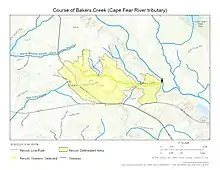
Course of Bakers Creek (Cape Fear River tributary)
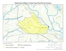
Watershed of Bakers Creek (Cape Fear River tributary)
References
- "GNIS Detail - Bakers Creek". geonames.usgs.gov. US Geological Survey. Retrieved 10 September 2020.
- "Bakers Creek Topo Map in Bladen". TopoZone. Locality, LLC. Retrieved 10 September 2020.
- "ArcGIS Web Application". epa.maps.arcgis.com. US EPA. Retrieved 10 September 2020.
- "Bakers Creek Watershed Report". US EPA Geoviewer. US EPA. Retrieved 10 September 2020.
This article is issued from Wikipedia. The text is licensed under Creative Commons - Attribution - Sharealike. Additional terms may apply for the media files.