Athlone to Mullingar Cycleway
The Athlone to Mullingar Cycleway (also known as Old Rail Trail)[2][3] is a long-distance cycling and walking trail in County Westmeath, which forms a section of the Dublin-Galway Greenway. It is a 42 kilometres long rail-trail over the disused Athlone-Mullingar rail line beginning in Athlone and ending in Mullingar.[4][5]
| Athlone to Mullingar Cycleway | |
|---|---|
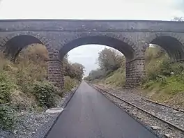
 Bridge on the greenway | |
| Length | 42 kilometres (26 miles)[1] |
| Location | County Westmeath, Ireland |
| Use | Cycling, walking |
| Difficulty | Easy |
| Season | Any |
| Surface | Tarmac |
| Website | Athlone.ie - Old Rail Trail |

History


The route was originally opened c. 1850 as a railway line by the Midland Great Western Railway and was the first to reach Athlone from Dublin.[6] The line was closed c. 1987 with trains using the former Great Southern and Western Railway line to reach Athlone.[7]
The Moate-Garrycastle section was officially opened by Taoiseach Enda Kenny in October 2015.[8][9][10] In September 2015 the Westmeath Independent reported that the greenway could provide a "€15m boost" to the local economy.[11]
The section was extended up to Ballymahon road (White gates) in December 2016, with plans to eventually extend into Athlone town.[12][13]
As of 2015, plans by a community development organisation in Kilbeggan, County Westmeath, were underway to connect the Greenway to the Offaly Cycleways at Kilbeggan with a greenway to Tullamore, County Offaly.[14] Work was planned to begin by summer 2016.[14][15]
A new bridge to cross the River Shannon in Athlone was allocated €8.1m funding and was planned to begin construction in June 2021.[16][17][18][19]
Access points
The following is a list of the access points to the cycleway.[20]
| Location | Distance from Athlone (km) | Distance to Mullingar (km) | Coordinates |
|---|---|---|---|
| Abbey Road, Athlone | - | 43 | 53.426547, -7.942494[21] |
| Whitegates, Athlone | - | 42 | 53.427995, -7.931805 |
| Garrycastle, Athlone | - | 40 | 53.422411, -7.899979 |
| Mount Temple | 6 | 34 | 53.402258, -7.816096 |
| Maghermore | 8 | 32 | 53.399294, -7.781841 |
| Moate (Dún na Sí Park) | 12 | 28 | 53.398406, -7.736041 |
| Moate (Station) | 12 | 28 | 53.399177, -7.723514 |
| Rosemount | 18 | 22 | 53.415931, -7.641321 |
| Lisnagree | 21 | 19 | 53.415931, -7.641321 |
| Streamstown | 23 | 17 | 53.435258, -7.570478 |
| Garhy (R391) | 26.2 | 13.8 | 53.450029, -7.531310 |
| Castletown Station | 28 | 12 | 53.454793, -7.522229 |
| Dysart | 30 | 10 | 53.476641, -7.480747 |
| Ballinea | 36 | 4 | 53.502709, -7.431523 |
| Bellmount | 37.2 | 2.8 | 53.508298, -7.403209 |
| Kilpatrick | 38.4 | 1.6 | 53.509364, -7.390320 |
| Mullingar Newbrook (Canal Link) | 40 | - | 53.517095, -7.368273 |
| Mullingar Newbrook (Roundabout Access) | 42 | - | 53.509364, -7.390320 |
See also
References
- "Old Rail Trail Westmeath" (PDF). Westmeath County Council. 2016. Archived from the original (PDF) on 12 January 2016. Retrieved 10 January 2020.
- O'Shea, Susan (23 December 2019). "12 things to get you off the couch this Christmas". IrishExaminer.com.
- "Westmeath County Council - News". Archived from the original on 22 December 2015. Retrieved 19 October 2015.
- "Midlands Greenway official opening on October 18". Westmeath Examiner. 11 October 2015. Archived from the original on 14 October 2015. Retrieved 14 October 2015.
- "Work underway at Moate Railway Station". Athlone Advertiser. 9 July 2015. p. 4. Archived from the original on 10 July 2015. Retrieved 9 July 2015 – via pagesuite-professional.co.uk.
- Casserley, H. C. (1974). Outline of Irish Railway History. Newton Abbot & North Pomfret: David & Charles. pp. 95–96. ISBN 0715363778. OCLC 249227042.
- "Clara Heritage Group : **(Part 4) - Full Steam Ahead to Streamstown (Well almost)**". www.facebook.com.
- "Taoiseach to officially open Greenway this Sunday". 5 October 2015. Archived from the original on 16 October 2015. Retrieved 16 October 2015.
- "Taoiseach to perform official opening of Mullingar to Garrycastle cycleway". Shannonside FM. 11 September 2015. Archived from the original on 5 October 2015. Retrieved 5 October 2015.
- Cusack, Adrian (18 May 2015). "Countdown is on to opening of Athlone to Mullingar cycleway". Westmeath Independent. Retrieved 4 June 2015.
- Cusack, Adrian (2 September 2015). "local greenway could provide '€15m boost'". Westmeath Independent. Archived from the original on 3 September 2015. Retrieved 3 September 2015.
- Fagan, Ronan (30 August 2018). "Greenway extension progress boost as funding is announced". Athlone Advertiser. Archived from the original on 30 August 2018. Retrieved 30 August 2018.
- "Council looking to push forward plans for extension of Greenway". Athlone Advertiser. 5 May 2016. p. 1. Archived from the original on 6 May 2016. Retrieved 5 May 2016 – via pagesuite-professional.co.uk.
- "Kilbeggan track could be 'midlands Greenway'". Westmeath Examiner. 6 February 2015. Retrieved 13 February 2014.
- "Taoiseach to open Athlone-Mullingar Greenway this afternoon". Shannonside FM. 18 October 2015. Archived from the original on 11 December 2015.
- Fagan, Ronan (12 November 2020). "Significant funding allocated towards the construction of new town bridge". Athlone Advertiser. Archived from the original on 13 November 2020.
- Grace, Robert (10 December 2015). "Councillors welcome latest proposed design for Athlone's cycleway bridge". Athlone Advertiser. Archived from the original on 11 December 2015.
- "Galway to Dublin Cycleway". Westmeath County Council. 2017. Archived from the original on 11 July 2017. Retrieved 11 July 2017.
- Daly, Maria (9 October 2014). "Council confirm plans for new towncentre bridge as part of cycleway". Athlone Advertiser. Retrieved 9 October 2014.
- "Old Rail Trail - Route Map". Westmeath County Council. 2022. Archived from the original on 23 February 2022.
- "Next greenway phase could open by Easter". Westmeath Independent.