Anaktorio
Anaktorio (Greek: Ανακτόριο) is a former municipality in Aetolia-Acarnania, West Greece, Greece. Since the 2011 local government reform it is part of the municipality Aktio-Vonitsa, of which it is a municipal unit.[2] The municipal unit has an area of 214.112 km2.[3] The municipal unit is mainly flat and has a total population of 9,129 residents according to the 2011 census, roughly half of which are found in the town of Vonitsa.
Anaktorio
Ανακτόριο | |
|---|---|
 Anaktorio Location within the regional unit 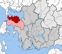 | |
| Coordinates: 38°55′N 20°53′E | |
| Country | Greece |
| Administrative region | West Greece |
| Regional unit | Aetolia-Acarnania |
| Municipality | Aktio-Vonitsa |
| • Municipal unit | 241.1 km2 (93.1 sq mi) |
| Population (2011)[1] | |
| • Municipal unit | 9,129 |
| • Municipal unit density | 38/km2 (98/sq mi) |
| Time zone | UTC+2 (EET) |
| • Summer (DST) | UTC+3 (EEST) |
| Postal code | 300 02 |
| Area code(s) | 26430 |
Subdivisions
The municipal unit Anaktorio is subdivided into the following communities (constituent villages in brackets):
- Vonitsa (Vonitsa, Aktio, Nea Kamarina)
- Agios Nikolaos Vonitsis
- Drymos (Drymos, Petra)
- Thyrio (Thyrio, Gourgouvli)
- Monastiraki (Monastiraki, Korpi)
- Paliampela
References
- "Απογραφή Πληθυσμού - Κατοικιών 2011. ΜΟΝΙΜΟΣ Πληθυσμός" (in Greek). Hellenic Statistical Authority.
- "ΦΕΚ B 1292/2010, Kallikratis reform municipalities" (in Greek). Government Gazette.
- "Population & housing census 2001 (incl. area and average elevation)" (PDF) (in Greek). National Statistical Service of Greece. Archived from the original (PDF) on 2015-09-21.
This article is issued from Wikipedia. The text is licensed under Creative Commons - Attribution - Sharealike. Additional terms may apply for the media files.