Alzette
The Alzette (French pronunciation: [alzɛt]; Luxembourgish: Uelzecht [ˈuəltsəɕt]; German: Alzig [ˈaltsɪç]) is a river with a length of 73 kilometres (45 mi) in France and Luxembourg. It is a right tributary of the Sauer (a tributary to the Moselle), and ultimately to the Rhine.
| Alzette | |
|---|---|
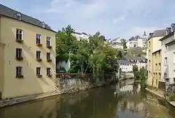 The Alzette winding through Grund, Luxembourg | |
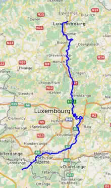 Course of the Alzette | |
| Location | |
| Countries | |
| Physical characteristics | |
| Source | |
| • location | Thil |
| • elevation | 305 m (1,001 ft) |
| Mouth | Sauer |
• location | Ettelbruck |
• coordinates | 49°50′54″N 6°6′43″E |
| Length | 73 km (45 mi) |
| Basin features | |
| Progression | Sauer→ Moselle→ Rhine→ North Sea |
| Tributaries | |
| • left | Mess, Pétrusse, Eisch, Attert, Wark |
It rises in Thil near the town Villerupt in the Meurthe-et-Moselle département, France. It crosses the border with Luxembourg after 2.7 km (1.7 mi).[1] At Lameschmillen (near Bergem) it is joined by the Mess. It flows through the Luxembourgish towns Esch-sur-Alzette, Luxembourg City and Mersch, and empties into the Sauer near Ettelbruck.
The rocky cliffs above the Alzette in Luxembourg are called 'Bock'. This name was given to the Casemates du Bock;[2] a honeycomb of tunnels colloquially named 'Paula', which runs under the ruins of the Fortress of Luxembourg. It protected Luxembourg City for centuries.
References
- Sandre. "Fiche cours d'eau - L'Alzette (A89-0200)".
- Centre, UNESCO World Heritage. "City of Luxembourg: its Old Quarters and Fortifications". UNESCO World Heritage Centre. Retrieved 2022-05-13.