Acacia densiflora
Acacia densiflora is a shrub of the genus Acacia and the subgenus Plurinerves that is endemic to an area of south western Australia.
| Acacia densiflora | |
|---|---|
| Scientific classification | |
| Kingdom: | Plantae |
| Clade: | Tracheophytes |
| Clade: | Angiosperms |
| Clade: | Eudicots |
| Clade: | Rosids |
| Order: | Fabales |
| Family: | Fabaceae |
| Subfamily: | Caesalpinioideae |
| Clade: | Mimosoid clade |
| Genus: | Acacia |
| Species: | A. densiflora |
| Binomial name | |
| Acacia densiflora | |
 | |
| Occurrence data from AVH | |
Description
The dense pungent shrub typically grows to a height of 0.4 to 1.2 metres (1 to 4 ft)[1] and has branchlets that are covered with matted woolly hairs. Like most species of Acacia it has phyllodes rather than true leaves. The evergreen, inclined to ascending phyllodes which are straight, flat and linear. The rigid and glabrous phyllodes are 2.5 to 6 cm (0.98 to 2.36 in) in length and 1 to 2 mm (0.039 to 0.079 in) wide and are coarsely pungent and have 16 closely parallel, yellowish coloured nerves. When it blooms it produces simple inflorescences that are found in pairs in the axils and have spherical flower-heads that have a diameter of 4 to 5 mm (0.16 to 0.20 in) and contain 15 to 18 golden coloured flowers. Following flowering linear to slightly curves seed pods form that are raised over and constricted between each of the seeds. The hairy and thinly crustaceous pods have a length of up to 4.5 cm (1.8 in) and a width of about 2.5 mm (0.098 in). The glossy black seeds inside have an elliptic shape with a length of around 3 mm (0.12 in).[2]
Taxonomy
The type specimen was collected from near Kellerberrin in 1897 by R.B.Leake.[2] This species along with Acacia dissona, Acacia eremophila, Acacia kalgoorliensis, Acacia hadrophylla and others all belong to the Acacia densiflora group of wattles.[2]
Distribution
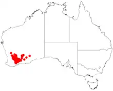
It is native to an area in the Wheatbelt and Goldfields-Esperance regions of Western Australia where it is found growing in sandy or gravelly sandy soils.[1] The distribution of the bulk of the population the shrub extends from around Wyalkatchem and Chiddarcooping in the north down to around Ongerup and Frank Hann National Park with outlying populations found as far east as Coolgardie as a part of mallee communities.[2]
See also
References
- "Acacia densiflora". FloraBase. Western Australian Government Department of Biodiversity, Conservation and Attractions.
- "Acacia densiflora". World Wide Wattle. Western Australian Herbarium. Retrieved 10 November 2020.