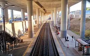
22nd Street station (Caltrain)
22nd Street station is a Caltrain commuter rail station located south of 22nd Street between the Dogpatch and Potrero Hill neighborhoods of San Francisco, California beneath the Interstate 280 freeway viaduct. The only below-grade Caltrain station, it is bracketed on the north and south by two tunnels which take the line under the eastern slope of Potrero Hill. The station is also served by Muni routes 48 and 55.[3]
22nd Street | ||||||||||||||||||||||||||||||
|---|---|---|---|---|---|---|---|---|---|---|---|---|---|---|---|---|---|---|---|---|---|---|---|---|---|---|---|---|---|---|
 22nd Street station under the I-280 viaduct in November 2017 | ||||||||||||||||||||||||||||||
| General information | ||||||||||||||||||||||||||||||
| Location | 1149 22nd Street San Francisco, California | |||||||||||||||||||||||||||||
| Coordinates | 37°45′26″N 122°23′33″W | |||||||||||||||||||||||||||||
| Owned by | Peninsula Corridor Joint Powers Board | |||||||||||||||||||||||||||||
| Line(s) | Peninsula Subdivision[1] | |||||||||||||||||||||||||||||
| Platforms | 2 side platforms | |||||||||||||||||||||||||||||
| Tracks | 2 | |||||||||||||||||||||||||||||
| Connections | ||||||||||||||||||||||||||||||
| Construction | ||||||||||||||||||||||||||||||
| Structure type | Below-grade | |||||||||||||||||||||||||||||
| Parking | Street parking | |||||||||||||||||||||||||||||
| Bicycle facilities | 27 racks, lockers, Bay Wheels station | |||||||||||||||||||||||||||||
| Accessible | No | |||||||||||||||||||||||||||||
| Other information | ||||||||||||||||||||||||||||||
| Fare zone | 1 | |||||||||||||||||||||||||||||
| History | ||||||||||||||||||||||||||||||
| Opened | 1907 | |||||||||||||||||||||||||||||
| Previous names | 23rd Street | |||||||||||||||||||||||||||||
| Original company | Southern Pacific | |||||||||||||||||||||||||||||
| Passengers | ||||||||||||||||||||||||||||||
| 2018 | 1,977 per weekday[2] | |||||||||||||||||||||||||||||
| Services | ||||||||||||||||||||||||||||||
| ||||||||||||||||||||||||||||||
| ||||||||||||||||||||||||||||||
| Location | ||||||||||||||||||||||||||||||
The station opened when the Southern Pacific Railroad built the Bayshore Cutoff in 1907. The station was originally known as 23rd Street.[4] The former wooden stairways were replaced with metal stairs in 2007.[5]
The station is reached only by stairways from 22nd Street and Iowa Street – there are no ramps or elevators between the platforms and street level – and is thus not accessible.[5] The narrow stairways create bottlenecks, especially when northbound trains arrive.[5] A December 2021 study recommended the installation of ramps as an interim accessibility measure pending future reconstruction or relocation.[6]
Under the Pennsylvania Avenue alternative of the Downtown Rail Extension project, Caltrain tracks would be placed in a new tunnel north of 22nd Street. The existing station would be replaced by a new station, either at the existing site, or potentially north at Mariposa Street or south at Cesar Chavez Street.[7]
References
- SMA Rail Consulting (April 2016). "California Passenger Rail Network Schematics" (PDF). California Department of Transportation. p. 13.
- "2018 Annual Count Key Findings Report" (PDF). Caltrain. 2018. Archived from the original (PDF) on May 20, 2020. Retrieved October 17, 2018.
- "Muni Service Map". SFMTA. July 9, 2022. Retrieved December 2, 2022.
- "Southern Pacific Peninsula Time Tables". Southern Pacific Lines. April 1, 1978. Archived from the original on July 1, 2007.
- Eisen|Letunic (October 2, 2008). "Appendix B: Station Details". Caltrain Bicycle Access & Parking Plan (PDF). Peninsula Corridor Joint Powers Board. pp. 49–50.
- "22nd St Station ADA Access Improvement Feasibility Study: SFCTA Update" (PDF). Peninsula Corridor Joint Powers Board. October 2021.
- Schneider, Benjamin (October 8, 2021). "A new Caltrain station in the Bayview: Here's the plan". San Francisco Examiner.
