Örebro Municipality
Örebro Municipality (Swedish: Örebro kommun) is a municipality in Örebro County in central Sweden. Its seat is located in the city of Örebro.
Örebro Municipality
Örebro kommun | |
|---|---|
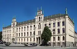 Örebro Town Hall | |
 Coat of arms | |
 | |
| Coordinates: 59°16′N 15°13′E | |
| Country | Sweden |
| County | Örebro County |
| Seat | Örebro |
| Area | |
| • Total | 1,620.6 km2 (625.7 sq mi) |
| • Land | 1,373.15 km2 (530.18 sq mi) |
| • Water | 247.45 km2 (95.54 sq mi) |
| Area as of 1 January 2014. | |
| Population (31 December 2021)[2] | |
| • Total | 156,987 |
| • Density | 97/km2 (250/sq mi) |
| Time zone | UTC+1 (CET) |
| • Summer (DST) | UTC+2 (CEST) |
| ISO 3166 code | SE |
| Province | Närke and Västmanland |
| Municipal code | 1880 |
| Website | www.orebro.se |
The municipality was created from the City of Örebro and surrounding rural municipalities in 1971 and with some areas added in 1974 it had an area of 1,840 km2. In 1995 the municipality was split in two when Lekeberg Municipality was recreated in its boundaries from 1967.
Localities
Towns and localities with more than 800 inhabitants:
- Örebro 107,038 (seat)
- Hovsta 2,700
- Odensbacken 1,400
- Vintrosa 1,300
- Mosås 900
- Stora Mellösa 800
Others:
- Latorp 500
Demographics
Population development
| Year | Population | ||||||||
|---|---|---|---|---|---|---|---|---|---|
| 1970 | 117,696 | ||||||||
| 1975 | 117,837 | ||||||||
| 1980 | 116,969 | ||||||||
| 1985 | 118,043 | ||||||||
| 1990 | 120,944 | ||||||||
| 1995 | 119,635 | ||||||||
| 2000 | 124,207 | ||||||||
| 2005 | 127,733 | ||||||||
| 2010 | 135,460 | ||||||||
| 2015 | 144,200 | ||||||||
| 2020 | 156,381 | ||||||||
|
Source: SCB - Folkmängd efter region och år. | |||||||||
2022 by district
This is a demographic table based on Örebro Municipality's electoral districts in the 2022 Swedish general election sourced from SVT's election platform, in turn taken from SCB official statistics.[3]
Residents include everyone registered as living in the district, regardless of age or citizenship status.[3] Valid voters indicate Swedish citizens above the age of 18 who therefore can vote in general elections.[3] Left vote and right vote indicate the result between the two major blocs in said district in the 2022 general election. Employment indicates the share of people between the ages of 20 and 64 who are working taxpayers.[3] Foreign background denotes residents either born abroad or with two parents born outside of Sweden.[3] Median income is the received monthly income through either employment, capital gains or social grants for the median adult above 20, also including pensioners in Swedish kronor.[3] College graduates indicates any degree accumulated after high school.[3]
In total there were 117,940 Swedish citizen adults eligible to vote.[3] The political demographics were 52.1 % for the left bloc and 46.1 % for the right bloc.[3]
| Location | Residents | Valid voters | Left vote | Right vote | Employed | SV parents | 1st/2nd gen | Income | College |
|---|---|---|---|---|---|---|---|---|---|
| % | % | % | % | % | % | ||||
| Adolfsberg V | 1,906 | 1,353 | 41.4 | 58.0 | 89 | 87 | 13 | 35,805 | 64 |
| Adolfsberg Ö | 1,570 | 1,178 | 48.4 | 51.3 | 88 | 91 | 9 | 32,191 | 63 |
| Almby | 1,269 | 963 | 56.2 | 42.7 | 76 | 85 | 15 | 25,262 | 66 |
| Asker | 864 | 677 | 36.5 | 62.7 | 86 | 95 | 5 | 23,963 | 25 |
| Axberg | 1,842 | 1,396 | 45.3 | 53.1 | 88 | 91 | 9 | 29,153 | 41 |
| Baronbackarna | 2,161 | 1,354 | 69.4 | 25.3 | 59 | 34 | 66 | 15,458 | 26 |
| Bettorp | 1,163 | 918 | 47.2 | 52.2 | 88 | 77 | 23 | 30,417 | 56 |
| Birgitta | 1,549 | 1,344 | 52.5 | 46.0 | 82 | 85 | 15 | 27,287 | 60 |
| Björkhaga | 1,775 | 1,318 | 57.8 | 40.8 | 82 | 84 | 16 | 27,970 | 52 |
| Brickebacken N | 1,521 | 932 | 60.4 | 33.4 | 54 | 36 | 64 | 13,555 | 32 |
| Brickebacken S | 1,935 | 1,190 | 62.5 | 35.2 | 58 | 39 | 61 | 16,218 | 27 |
| Brickeberg | 1,627 | 1,126 | 54.9 | 42.7 | 72 | 63 | 37 | 24,912 | 58 |
| Bromsplan | 1,423 | 1,191 | 56.4 | 41.8 | 75 | 78 | 22 | 23,551 | 46 |
| Brunnsgärdet | 1,749 | 1,408 | 50.6 | 48.3 | 90 | 87 | 13 | 29,178 | 55 |
| Centralstationen | 1,515 | 1,292 | 52.5 | 45.6 | 81 | 76 | 24 | 24,989 | 50 |
| Centrum | 1,545 | 1,341 | 52.8 | 46.2 | 83 | 83 | 17 | 28,103 | 52 |
| Ekeby Almby | 2,416 | 1,487 | 42.9 | 56.8 | 92 | 87 | 13 | 35,895 | 66 |
| Eklunda | 1,499 | 1,204 | 46.6 | 52.8 | 84 | 88 | 12 | 31,002 | 60 |
| Ervalla | 1,165 | 878 | 43.2 | 55.6 | 86 | 92 | 8 | 26,942 | 33 |
| Eyra | 1,488 | 1,268 | 46.2 | 53.0 | 83 | 84 | 16 | 29,488 | 58 |
| Gamla Hjärsta | 1,472 | 1,090 | 56.1 | 43.7 | 82 | 76 | 24 | 29,320 | 53 |
| Glanshammar-Ödeby | 2,120 | 1,658 | 44.4 | 54.7 | 89 | 94 | 6 | 28,430 | 42 |
| Grönpepparparken | 1,876 | 1,373 | 50.4 | 48.8 | 76 | 69 | 31 | 25,582 | 55 |
| Gustavsvik | 1,270 | 1,509 | 41.0 | 58.4 | 82 | 77 | 23 | 25,771 | 59 |
| Gällersta | 2,032 | 1,487 | 41.2 | 57.3 | 87 | 86 | 14 | 30,551 | 48 |
| Hagaby-Ringstorp | 1,481 | 1,157 | 48.5 | 50.8 | 88 | 91 | 9 | 32,276 | 57 |
| Hagastrand | 997 | 923 | 55.0 | 44.8 | 81 | 82 | 18 | 25,893 | 48 |
| Heden | 1,253 | 966 | 44.3 | 53.5 | 72 | 49 | 51 | 22,644 | 35 |
| Hovsta V | 1,525 | 1,080 | 53.4 | 44.9 | 89 | 89 | 11 | 32,113 | 63 |
| Hovsta Ö | 1,539 | 1,088 | 52.9 | 45.9 | 87 | 86 | 14 | 29,100 | 55 |
| Karla | 1,934 | 1,493 | 58.1 | 39.8 | 76 | 64 | 36 | 21,174 | 44 |
| Karlslund | 1,481 | 1,165 | 53.0 | 46.0 | 84 | 76 | 24 | 25,396 | 43 |
| Kil | 1,290 | 1,012 | 43.3 | 55.9 | 89 | 91 | 9 | 28,563 | 43 |
| Kilsmo-Brevens Bruk | 730 | 599 | 40.4 | 57.9 | 72 | 87 | 13 | 19,985 | 24 |
| Krämartorget | 1,439 | 1,274 | 56.8 | 40.7 | 73 | 70 | 30 | 22,231 | 39 |
| Ladugårdsängen V | 1,889 | 1,494 | 55.4 | 42.7 | 80 | 79 | 21 | 26,357 | 53 |
| Ladugårdsängen Ö | 1,576 | 1,316 | 50.6 | 47.6 | 82 | 78 | 22 | 25,987 | 50 |
| Lillkyrka | 920 | 692 | 47.5 | 51.5 | 89 | 93 | 7 | 27,857 | 44 |
| Lillån V | 1,816 | 1,283 | 48.3 | 50.2 | 88 | 81 | 19 | 29,486 | 51 |
| Lillån Ö | 2,062 | 1,429 | 47.4 | 51.7 | 88 | 87 | 13 | 33,287 | 59 |
| Lindhult | 1,777 | 1,312 | 41.1 | 57.6 | 88 | 84 | 16 | 29,209 | 49 |
| Lundby N | 1,473 | 1,162 | 58.4 | 39.8 | 82 | 60 | 40 | 23,873 | 39 |
| Lundby S | 1,382 | 1,026 | 51.3 | 47.2 | 79 | 62 | 38 | 25,151 | 39 |
| Längbrotorg | 1,335 | 1,116 | 56.9 | 41.6 | 79 | 80 | 20 | 24,151 | 45 |
| Lännäs-Vinön | 958 | 827 | 42.1 | 56.6 | 81 | 91 | 9 | 23,863 | 37 |
| Marieberg | 1,851 | 1,295 | 42.4 | 56.8 | 91 | 90 | 10 | 31,651 | 48 |
| Markbacken | 1,358 | 819 | 66.0 | 30.8 | 63 | 32 | 68 | 16,640 | 30 |
| Mellringe | 1,553 | 1,171 | 44.7 | 54.2 | 84 | 77 | 23 | 26,806 | 45 |
| Mikael | 1,406 | 1,111 | 54.6 | 43.6 | 83 | 83 | 17 | 28,149 | 50 |
| Mosås | 2,121 | 1,418 | 41.8 | 57.4 | 88 | 86 | 14 | 30,234 | 48 |
| Nasta | 1,642 | 1,280 | 46.9 | 52.4 | 86 | 88 | 12 | 31,105 | 53 |
| Norrby | 1,542 | 1,102 | 58.1 | 39.5 | 69 | 65 | 35 | 19,782 | 37 |
| Norrbyås | 753 | 588 | 45.2 | 54.2 | 89 | 92 | 8 | 29,773 | 44 |
| Nya Hjärsta | 1,603 | 1,171 | 50.6 | 48.3 | 87 | 69 | 31 | 30,415 | 50 |
| Nyponlunden | 1,380 | 1,003 | 42.8 | 56.2 | 81 | 49 | 51 | 27,533 | 43 |
| Näbbtorget | 1,406 | 1,190 | 55.8 | 42.5 | 67 | 67 | 33 | 19,598 | 39 |
| Näsby | 1,756 | 1,254 | 56.8 | 42.5 | 85 | 86 | 14 | 31,771 | 69 |
| Odensbacken | 1,741 | 1,374 | 39.9 | 59.0 | 78 | 87 | 13 | 22,217 | 28 |
| Olaus Petri | 1,226 | 1,056 | 58.5 | 39.7 | 69 | 70 | 30 | 19,422 | 34 |
| Ormesta | 1,339 | 929 | 49.4 | 50.2 | 89 | 90 | 10 | 32,294 | 63 |
| Oskarsparken | 1,468 | 1,330 | 52.7 | 46.5 | 78 | 88 | 12 | 26,819 | 57 |
| Oxhagen | 2,129 | 1,294 | 67.5 | 25.7 | 57 | 21 | 79 | 14,214 | 25 |
| Rinkaby | 718 | 532 | 47.5 | 50.1 | 89 | 94 | 6 | 30,493 | 47 |
| Rosta V | 1,549 | 1,160 | 59.5 | 38.1 | 72 | 77 | 23 | 23,840 | 41 |
| Rosta Ö | 1,606 | 1,296 | 58.6 | 40.7 | 78 | 79 | 21 | 24,771 | 48 |
| Rudbeck | 1,426 | 1,282 | 50.6 | 48.1 | 74 | 81 | 19 | 23,650 | 56 |
| Rynninge | 1,545 | 1,207 | 54.8 | 45.1 | 90 | 89 | 11 | 34,291 | 66 |
| Rynningeåsen | 1,742 | 1,273 | 59.9 | 39.5 | 85 | 83 | 17 | 29,041 | 65 |
| Slottet | 1,137 | 977 | 50.0 | 49.3 | 81 | 84 | 16 | 28,859 | 50 |
| Sofia | 1,089 | 991 | 50.4 | 48.6 | 80 | 84 | 16 | 26,250 | 57 |
| Solhaga | 1,272 | 1,054 | 65.2 | 33.9 | 79 | 78 | 22 | 22,545 | 45 |
| Stadsparken | 1,375 | 1,219 | 50.4 | 49.1 | 78 | 86 | 14 | 26,335 | 58 |
| Stora Mellösa | 2,088 | 1,614 | 46.3 | 52.4 | 85 | 94 | 6 | 25,659 | 39 |
| Svampen | 1,697 | 1,193 | 56.7 | 41.9 | 83 | 78 | 22 | 27,683 | 56 |
| Södermalm | 1,515 | 1,154 | 55.7 | 42.0 | 70 | 59 | 41 | 22,272 | 39 |
| Sörby N | 1,380 | 1,157 | 51.0 | 48.3 | 84 | 88 | 12 | 29,786 | 59 |
| Sörby S | 1,527 | 1,170 | 53.7 | 45.3 | 79 | 84 | 16 | 28,954 | 62 |
| Sörbyängen N | 1,385 | 1,078 | 54.4 | 44.6 | 85 | 81 | 19 | 29,153 | 58 |
| Sörbyängen S | 1,483 | 1,110 | 57.2 | 41.9 | 73 | 75 | 25 | 25,249 | 56 |
| Tegnér | 1,609 | 1,347 | 56.2 | 42.5 | 79 | 77 | 23 | 25,532 | 52 |
| Trängen | 1,465 | 1,136 | 60.9 | 37.6 | 71 | 59 | 41 | 23,751 | 38 |
| Tybble | 1,368 | 1,063 | 57.2 | 40.7 | 68 | 64 | 36 | 20,197 | 34 |
| Tybblelund | 1,931 | 1,363 | 52.5 | 46.1 | 78 | 86 | 14 | 29,846 | 73 |
| Tysslinge-Garphyttan | 1,995 | 1,473 | 52.7 | 46.7 | 84 | 88 | 12 | 27,763 | 41 |
| Tysslinge-Latorp | 1,412 | 1,025 | 53.3 | 45.7 | 90 | 94 | 6 | 29,477 | 48 |
| Universitetet | 1,873 | 1,474 | 60.4 | 37.5 | 38 | 64 | 36 | 5,477 | 79 |
| Universitetssjukhuset | 1,457 | 1,189 | 52.2 | 46.7 | 73 | 78 | 22 | 23,158 | 52 |
| Varberga V | 1,965 | 1,094 | 63.5 | 30.8 | 57 | 20 | 80 | 15,537 | 27 |
| Varberga Ö | 1,691 | 837 | 56.8 | 36.0 | 52 | 16 | 84 | 12,671 | 28 |
| Vasastan M | 1,497 | 1,312 | 55.4 | 43.0 | 77 | 76 | 24 | 21,399 | 43 |
| Vasastan N | 1,577 | 1,260 | 56.6 | 40.7 | 76 | 74 | 26 | 23,227 | 40 |
| Vasastan S | 1,461 | 1,271 | 54.0 | 45.2 | 80 | 85 | 15 | 24,869 | 49 |
| Vintrosa | 2,152 | 1,595 | 44.8 | 54.6 | 89 | 93 | 7 | 28,721 | 41 |
| Vivalla N | 2,211 | 1,181 | 67.7 | 16.6 | 49 | 15 | 85 | 12,136 | 23 |
| Vivalla V | 2,230 | 922 | 67.8 | 15.4 | 47 | 12 | 88 | 10,671 | 20 |
| Vivalla Ö | 2,658 | 1,466 | 70.8 | 11.8 | 46 | 12 | 88 | 11,084 | 17 |
| Västhaga | 1,437 | 1,216 | 56.0 | 42.5 | 64 | 68 | 32 | 18,067 | 30 |
| Åkullen | 1,384 | 1,162 | 57.1 | 41.2 | 75 | 76 | 24 | 22,641 | 44 |
| Örnsro | 1,599 | 1,354 | 56.9 | 41.4 | 72 | 72 | 28 | 22,096 | 42 |
| Österplan | 1,283 | 999 | 50.1 | 47.8 | 79 | 82 | 18 | 26,491 | 61 |
| Source: SVT[3] | |||||||||
Elections
From the 1994 election onwards there was a boundary change due to the split with Lekeberg Municipality. The exact results of Sweden Democrats were not listed at a municipal level by SCB from 1988 to 1998 due to the party's small size at the time. "Turnout" denotes the percentage of eligible people casting any ballots, whereas "Votes" denotes the number of valid votes only.
Riksdag
| Year | Turnout | Votes | V | S | MP | C | L | KD | M | SD | NyD | Left | Right |
|---|---|---|---|---|---|---|---|---|---|---|---|---|---|
| 1973[4] | 90.3 | 77,604 | 3.9 | 45.5 | 24.3 | 11.6 | 2.2 | 11.9 | 49.4 | 47.8 | |||
| 1976[5] | 91.5 | 80,670 | 4.1 | 44.5 | 23.8 | 12.3 | 1.6 | 13.2 | 48.6 | 49.3 | |||
| 1979[6] | 90.0 | 78,995 | 5.2 | 44.3 | 17.3 | 11.9 | 2.0 | 18.2 | 49.5 | 47.4 | |||
| 1982[7] | 91.0 | 80,089 | 5.5 | 47.2 | 1.8 | 14.7 | 6.8 | 2.9 | 20.8 | 52.7 | 42.3 | ||
| 1985[8] | 89.6 | 80,290 | 5.4 | 44.8 | 1.8 | 11.9 | 16.8 | 18.0 | 50.2 | 46.7 | |||
| 1988[9] | 86.5 | 78,201 | 6.4 | 43.2 | 5.0 | 10.1 | 15.3 | 3.9 | 15.0 | 54.6 | 40.4 | ||
| 1991[10] | 87.3 | 79,566 | 4.9 | 38.2 | 3.3 | 6.8 | 11.9 | 9.5 | 17.9 | 6.7 | 43.1 | 46.1 | |
| 1994[11] | 87.6 | 76,606 | 6.7 | 46.2 | 5.2 | 5.3 | 9.7 | 5.8 | 18.7 | 1.4 | 58.1 | 39.5 | |
| 1998[12] | 82.4 | 73,648 | 12.5 | 38.0 | 5.1 | 3.8 | 6.5 | 12.3 | 19.2 | 55.6 | 41.8 | ||
| 2002[13] | 82.4 | 76,771 | 8.9 | 41.7 | 5.2 | 4.6 | 14.2 | 10.1 | 12.0 | 1.8 | 55.8 | 40.9 | |
| 2006[14] | 83.7 | 80,630 | 6.0 | 38.0 | 6.0 | 6.3 | 8.7 | 8.1 | 21.0 | 3.5 | 50.0 | 44.1 | |
| 2010[15] | 86.2 | 87,778 | 5.8 | 34.1 | 5.8 | 4.8 | 7.6 | 7.0 | 26.0 | 5.5 | 45.7 | 45.4 | |
| 2014[16] | 86.9 | 92,429 | 5.7 | 32.4 | 8.4 | 5.1 | 5.4 | 6.2 | 21.0 | 11.6 | 46.5 | 37.7 | |
| 2018[17] | 87.8 | 98,428 | 8.5 | 31.5 | 4.8 | 8.1 | 5.7 | 7.7 | 17.9 | 14.4 | 52.8 | 45.7 |
Twin towns
Örebro's seven twin towns with the year of its establishing:
- (1946) Kolding Municipality, Denmark
- (1946) Drammen, Norway
- (1947) Lappeenranta (Villmanstrand), Finland
- (1979) Stykkishólmur, Iceland
- (2001) Łódź, Poland
- (2002) Yantai, China

- (2003) Terrassa, Spain
See also
- Statistics Sweden
- Nerikes Allehanda (newspaper)
- Julmust (Christmas beverage)
- List of hundreds of Sweden
References
- "Statistiska centralbyrån, Kommunarealer den 1 januari 2014" (in Swedish). Statistics Sweden. 2014-01-01. Archived from the original (Microsoft Excel) on 2016-09-27. Retrieved 2014-04-18.
- "Folkmängd i riket, län och kommuner 31 december 2021" (in Swedish). Statistics Sweden. February 22, 2022. Retrieved February 22, 2022.
- "Valresultat 2022 för Örebro i riksdagsvalet". SVT. 11 September 2022. Retrieved 8 January 2023.
- "Riksdagsvalet 1973" (PDF) (in Swedish). SCB. Retrieved 22 July 2017.
- "Riksdagsvalet 1976" (PDF) (in Swedish). SCB. Retrieved 22 July 2017.
- "Riksdagsvalet 1979" (PDF) (in Swedish). SCB. Retrieved 22 July 2017.
- "Riksdagsvalet 1982" (PDF) (in Swedish). SCB. Retrieved 22 July 2017.
- "Riksdagsvalet 1985" (PDF) (in Swedish). SCB. Retrieved 22 July 2017.
- "Riksdagsvalet 1988)" (PDF) (in Swedish). SCB. Retrieved 22 July 2017.
- "Riksdagsvalet 1991" (PDF) (in Swedish). SCB. Retrieved 22 July 2017.
- "Riksdagsvalet 1994" (PDF) (in Swedish). SCB. Retrieved 22 July 2017.
- "Riksdagsvalet 1998" (PDF) (in Swedish). SCB. Retrieved 21 July 2017.
- "Valresultat Riksdag Örebro kommun 2002" (in Swedish). Valmyndigheten. Retrieved 22 July 2017.
- "Valresultat Riksdag Örebro kommun 2006" (in Swedish). Valmyndigheten. Retrieved 22 July 2017.
- "Valresultat Riksdag Örebro kommun 2010" (in Swedish). Valmyndigheten. Retrieved 22 July 2017.
- "Valresultat Riksdag Örebro kommun 2014" (in Swedish). Valmyndigheten. Retrieved 22 July 2017.
- "Valresultat Riksdag Örebro kommun 2018" (in Swedish). Valmyndigheten. Retrieved 8 November 2021.
External links
- Örebro Municipality - Official site