Îles du Prince-de-Monaco
Les Îles du Prince-de-Monaco are a small group of 16 islands and islets belonging to France, located off Grande Terre, the principal island of the Kerguelen Islands.
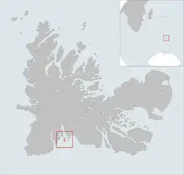 The isles position is highlighted on this Kerguelen Islands map. | |
| Geography | |
|---|---|
| Location | Indian Ocean |
| Coordinates | 49°36′S 69°14′E |
| Archipelago | Îles Kerguelen |
| Total islands | 2 |
| Major islands | Île Nord du Prince-de-Monaco ,Île Sud du Prince-de-Monaco |
| Area | 1 km2 (0.39 sq mi) |
| Length | 4 km (2.5 mi) |
| Width | 2 km (1.2 mi) |
| Coastline | 10 km (6 mi) |
| Highest elevation | 99 m (325 ft).[1] |
| Highest point | Unnamed hill |
| Administration | |
| District | Îles Kerguelen |
| Demographics | |
| Demonym | De Île du Prince-de-Monaco |
| Population | 0 |
They are located in the Audierne bay around 0.5 kilometres (1,600 feet) from the Bourbonnais point. The two main isles of the group are separated by a narrow strait and on the southern island, l'Île Sud du Prince-de-Monaco, an unnamed hill reaches an elevation of 99 metres (325 feet) above sea level.
Their name was chosen by Raymond Rallier du Baty in 1908/1909 to honour Albert I, Prince of Monaco.[2]
References
- General view of non-metropolitan France, Maison de la Géographie.
- Kerguelen islands map, Géoportail IGN
- Toponymie des Terres australes, by the Commission territoriale de toponymie and Gracie Delepine, August 1973, page 97
This article is issued from Wikipedia. The text is licensed under Creative Commons - Attribution - Sharealike. Additional terms may apply for the media files.