Satellite Applications
Satellites support a number of applications including:
- • Communications systems
- • Broadcasting systems
- • Remote sensing
- • Global positioning and navigation
- • Search and rescue
- • Weather and pollution monitoring
- • Surveillance
Some suggested topics .TV Broadcasting
Satellite Frequency Bands
Satellite Link Budgets
DBS (Direct Broadcast Satellite)
VSAT (Very Small Aperture Terminals)
GPS (Global Positioning System)
It refers to a system of satellites that constantly transmit a signal, and a GPS terminal that picks up those signals and calculates its position on Earth by measuring the distance between itself and two or more GPS satellites (by measuring the time it takes to receive the signals).
Satellite Orbits
Geostationary Orbit
A satellite which orbits around the Earth at the same rate that the Earth turns is known as a synchronous orbit. Synchronous orbits can be of any inclination. If they are polar orbiting, the satellite will appear to be over the same spot at the same time every day.
Remote sensing satellites can be place in orbits that are synchronous with the Earth’s rotation over a longer period than a day, and thus will be able to view the entire ground surface over a number of orbits.
If a geosynchronous orbit is placed over the equator, something very interesting happens. The satellite will appear to stop moving in the sky. This is referred to as a geostationary orbit.
The gravitational acceleration of an object as a function of altitude is:

- where:
- equatorial radius of the Earth (6378.388 km)

- radius at the satellite position

- Earth's gravitational constant (9.80665 m/sec2)

The centrifugal acceleration on a satellite is given by:

- where:
- angular velocity in radians/sec

- time for 1 orbit (86400 seconds [24 hrs] for geostationary orbit)

For a stable orbit, the two forces associated with these accelerations must be equal

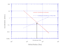
Solving for rs we obtain:
![{\displaystyle r_{s}={\sqrt[{3}]{\left({\frac {r_{e}T_{s}}{2\pi }}\right)^{2}g}}={\sqrt[{}]{\left({\frac {6378\ km\times 86400\ \sec }{2\pi }}\right)^{2}9.8065\ m/\sec ^{2}}}=42,254.22\ km}](../../I/503420a7207631b0d52eacbaeae7235df6c0f10b.svg)
Therefor the height above the Earth is 42,254 km - 6378 km = 35,876 km or 22,292 miles.
The velocity of a satellite in a circular orbit is given by:
This works out to 3.073 km/Sec for a satellite in a geostationary orbit.
Path Length
The transmission path length can be found by applying Pythagorean Theorem:
In actual practice, the angle of elevation must be at least 5 degrees above the horizon. Therefore the actual geometry is closer to:
By applying the law of sines, a better approximation of the maximum path length can be determined, as well as the minimum distance from the pole required to see the satellite.
Using the polar radius to calculate the total arc length of the Earth, with the polar curvature, we obtain an effective polar circumference of:
Which means that the minimum distance d from the pole, at which the satellite can be seen is:
It is evident from the sketch, that the further north one goes, the greater the signal path length through the atmosphere.
Molniya Orbit
The former USSR is not able to make great use of geostationary satellites, because of the northern latitude of the country. Consequently, communications satellites have required a slightly different approach. The term molniya means “flash of lightning”.
Sun Synchronous Orbit
Many satellites which require sunlight for imaging use sun-synchronous orbits. The sun-synchronous orbit provides a constant node-to-sun angle, and the satellite passage over a certain area occurs at the same time of the day.